

Corner Brook

SAM Member Since: December 2018
Area Protected: 1,118 acres
The City of Corner Brook is located on the west coast of Newfoundland, at the mouth of the Bay of Islands. The area was first surveyed by explorer Captain James Cook in 1767. The population of the city in 2016 was 19,806, making it the the 3rd largest city in the province. Corner Brook is known around the world as both a popular tourist attraction and one of the best places to live, work and do business. The city is the administrative headquarters of the Qalipu Mi`kmaq First Nations band government. Corner Brook has many environmental attractions including the Corner Brook Marsh interpretation site, the Corner Brook Gorge hiking trail and several other hikes and lookouts.
Conservation Areas
The City of Corner Brook has two designated Conservation Areas, and two designated Stewardship Areas, totaling approximately 1,118 acres. These are: the Wild Cove Conservation Area, the Hughes Brook Estuary Conservation Area, the Humber River Stewardship Area, and the Corner Brook Stream Stewardship Area.
The Wild Cove Conservation Area has an abundance of vegetation to support large populations of waterfowl. Commonly seen in the area are Greater scaup (Aythya marila) and a diversity of gull species. A unique fen southeast of the Wild Cove landfill site supports three rare plants including Rattlesnake Root (Prenanthes racemosa) and Northern Bog Aster (Symphyotrichum boreale) which are only known to be found in this one location in the province, as well as Showy Ladyslipper (Cypripedium reginae).
The Hughes Brook Estuary is a saltwater estuary/marsh at the outflow of Hughes Brook that encompasses some of the most valuable wildlife habitat within the City of Corner Brook. The estuary is home to muskrat, beavers, moose, dozens of songbird and waterfowl species, it is also known breeding habitat for rarer wildlife such as the Rusty blackbird (Euphagus carolinus), as well as being a scheduled Atlantic salmon (Salmo salar) river.
Unlike Conservation Areas, Stewardship Areas fall under the sole discretion of the municipal council. The intent of designating land as a Stewardship Area is to publicly highlight the environmental values of those lands, raise awareness about the important habitat it provides in some areas for wildlife, and the ongoing need for sustainable development, while acknowledging that development may occur.
The Humber River Stewardship Area encompasses the Humber River - a major waterway running through much of Western Newfoundland, originating in the Long-Range Mountains and winding first southeast and then southwest before emptying out into the Bay of Islands. The Humber River is one of the best scheduled salmon rivers in the world, and the health of the salmon that inhabit it rely on a healthy river and riparian ecosystem, as do the recreational users who take to the water every summer to enjoy the good weather, boating and fishing.
The Corner Brook Stream Stewardship Area is nestled in the heart of the City, winding its way throughout the city to its outflow into the Bay of Islands. Numerous organizations, businesses, and community interest groups have invested time, effort, and resources into the development of these beloved community lands and a network of trails has been established along much of its extent. These continued efforts have led the site to becoming a rich brooding site for American black duck (Anas rubripes), and a consistent breeding site for Red-winged blackbird (Agelaius phoeniceus).
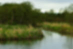
Looking into the marsh at Wild Cove

Northern Bog Aster, Endangered (May 2010)

Explore Corner Brook
Conservation News
City of Corner Brook Signs Municipal Habitat Stewardship Agreement - Department of Fisheries and Land Resources
Four Newfoundland Communities Earn Provincial and National Nods for Municipal Conservation Efforts - Saltwire
Wildlife Watching
eBird Hotspot - Humber River Mouth
eBird Hotspot - Ballam Bridge Area
eBird Hotspot - Riverside Extension
eBird Hotspot - Stream Trail Network: Marsh
eBird Hotspot - Stream Trail Network: Glynmill Pond
eBird Hotspot - Stream Trail Network: O'Connell Drive Area
eBird Hotspot - Stream Trail Network: Margaret Bowater Park
eBird Hotspot - Stream Trail Network: Ginger Route
eBird Hotspot - Stream Trail Network: Participark
eBird Hotspot - Hughes Brook Estuary
eBird Hotspot - Wild Cove
eBird Hotspot - Wild Cove Road Marsh
eBird Hotspot - Wild Cove Road Old Clearing
eBird Hotspot - Wild Cove Beach
Resources
Corner Brook Kids Map
Download and print this pamphlet to use at your next community stewardship event

.png)